The Pacific Cyclonic Coexistence
It seems that the Pacific Ocean off the Mexican coast has decided to organize a welcome party for which no one, absolutely no one, sent their RSVP. The guests of honor are the tropical storms Priscilla and Raymond, who advanced on Thursday with the delicacy of an elephant in a china shop, threatening to bring heavy rains and flash floods in their wake. As if that were not enough, post-tropical cyclone Octave, which is already on its last legs, continues to lurk around the area, like that guest who does not want to leave at the end of the meeting. Meanwhile, on the other side of the continent, Tropical Storm Jerry is approaching the Windward Islands, because why have drama in one ocean when you can have it in two?
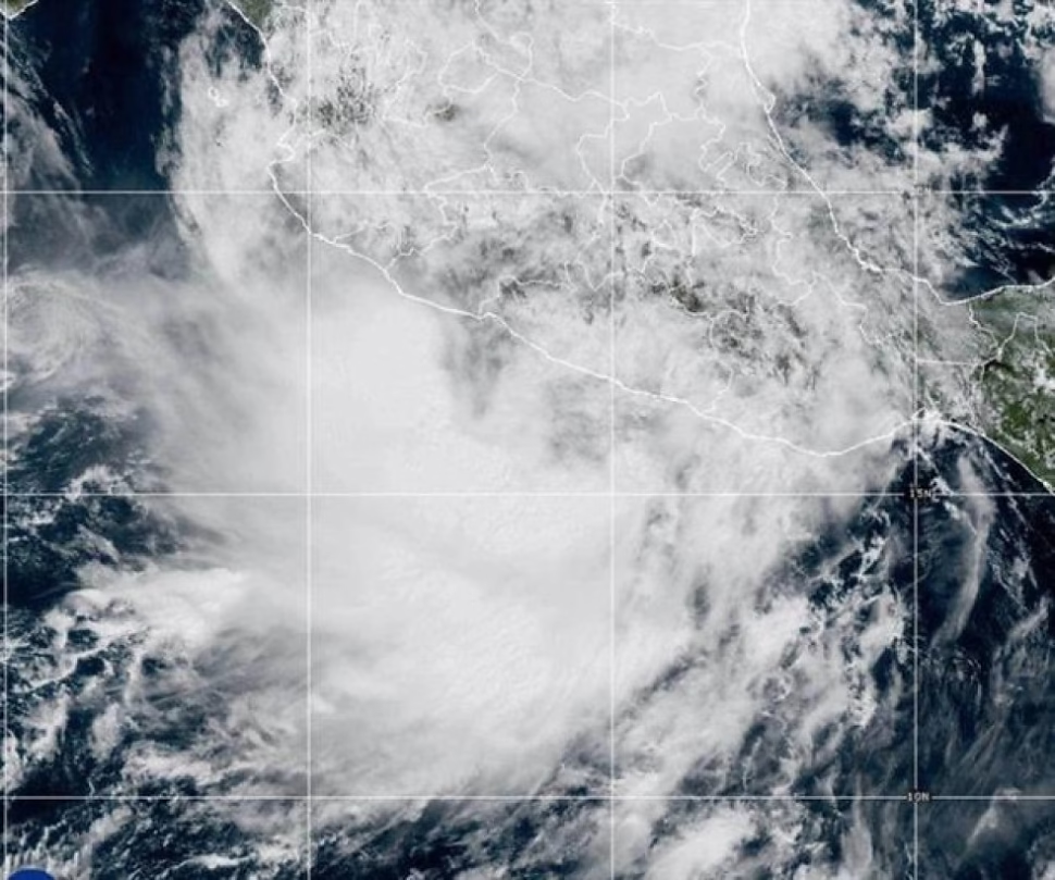
Raymond, the newcomer, was located about 190 kilometers south-southeast of Zihuatanejo, boasting its maximum sustained winds of 75 km/h and moving west-northwest at 22 km/h, according to the always formal United States National Hurricane Center (NHC). One can almost imagine him with a little wind chignon, presenting his credentials. But the real star of the show could be Priscilla, who, after bordering on Category 3 on Tuesday – a true ocean diva – was due to a tropical storm on Wednesday. How capricious is nature. Its calmer remains are expected to move toward the southwestern United States, where it could cause flash flooding. A gentle reminder that what happens in the Pacific does not stay in the Pacific.
The Atlantic is not far behind in the popularity contest
And so that the Pacific does not monopolize all the attention, the Atlantic presents its own candidate: Tropical Storm Jerry. With maximum sustained winds of 100 km/h, it was moving in a west-northwest direction at 30 km/h, passing near or northeast of the Windward Islands. This weather system is forecast to strengthen and become a hurricane on Saturday. Congratulations, Jerry! You’ll get your promotion from storm to hurricane just before the weekend.
Authorities on the French Caribbean island of Guadeloupe, with an optimism that borders on the heroic, have already warned of power outages, noting that the island’s grid is already dealing with generation problems and that bad weather will obviously make them worse. Because nothing solves technical problems like a good tropical storm. Tropical storm watches and warnings have been issued for a long list of paradise destinations such as Barbuda, Anguilla, Saint Barthelemy, Saint Martin and Antigua, turning an idyllic vacation into an all-inclusive survival adventure.
Coastal Party and Climate Change: The Collateral Spectacle
Off the southeast coast of the United States, a different but equally picturesque spectacle takes place: a unnamed storm (the poor one, always anonymous), combined with unusually high tides because, of course, the Moon is closer than usual to the Earth. This celestial and meteorological combination threatens to generate strong winds and coastal flooding, especially in the vulnerable Outer Banks of North Carolina and frequently flooded Charleston, South Carolina. In Charleston, forecasters predict a Friday morning high tide of 8 feet, which will be the 13th highest tide in more than a century of records. The city, with admirable resignation, already offered free parking in some garages. By Thursday morning, the tide, which was lower, had already flooded about a dozen streets. It’s like a dress rehearsal for Friday’s deluge.
But the real drama is on North Carolina’s Outer Banks, where the worst weather is expected to begin Friday and continue through the weekend. Forecasters warn the N.C. Highway is likely. 12 on Hatteras and Ocracoke Islands may have to close…again. And what would a stormy weekend be without the possibility of more houses falling into the sea? A total of 21 homes have collapsed since 2020 due to rising sea levels and shifting beaches, and ten of them were destroyed in the last month. The National Park Service reports it with a bureaucratic coldness that contrasts with the drama of watching your house be devoured by the ocean.
And as if the immediate picture were not colorful enough, meteorologists remind us that the cooling phenomenon of the Pacific Ocean, known as La Niña, has returned. This phenomenon, which can alter the global climate and enhance the formation of hurricanes, arrives just when there are approximately seven weeks left until the end of the 2025 Atlantic hurricane season. It may be a little late to have a massive influence on this season, but La Niña can always have other impacts, from heavy rains to droughts in various parts of the world. Because, clearly, we need more variables in this climate chaos equation.
As Raymond strolls off the southwestern coast of Mexico and Priscilla heads toward Baja California Sur, one can’t help but marvel at nature’s efficiency in creating spectacles on a grand scale. With flood alerts for parts of Arizona, California and Nevada, and a tropical storm warning associated with Raymond from Zihuatanejo to Cabo Corrientes, the message is clear: get ready, because the planet appears to have entered “extreme events” mode and has no plans to turn off the switch.
Did you like this tour of the turbulent meteorological panorama? Share this analysis on your social networks and help more people be aware of these natural phenomena. And if you want to continue exploring more content on extreme climate and its consequences, do not hesitate to browse our current affairs section. Information is the best tool to be prepared for the unpredictable.