Raymond arrives to ruin your weekend plans (and possibly your cell phone with so much alert)
It seems that nature decided that our weekend plans on the beach were too basic and added a touch of low-cost climate apocalypse. In the next few hours, Tropical Storm Raymond, which sounds more like the name of a boring accountant than a devastating natural phenomenon, will maintain its particular drama over the Mexican Pacific. Prepare for heavy rain in Jalisco, Colima and Michoacán, and “very heavy” rain (meteorologists’ favorite euphemism for “they’re going to need an ark”) in Nayarit.
But wait, there’s more, because what would a storm be without a gale that challenges your hairstyle? Wind gusts of 70 to 90 km/h are forecast on the coasts of Michoacán, Colima and Jalisco. To give you an idea, it is the speed at which they drive on the road, but applied to the air and with the bonus that it can throw a palm tree in your face. In Nayarit and Sinaloa they will be more modest, 40 to 60 km/h, enough to blow away your umbrella and your dignity.
The sea is also bad and it is not because of its existential problems
In its afternoon report, the National Meteorological Service (SMN), which is like your friends’ chat group but for natural disasters, warned that the swell will be between 3 and 4 meters on the coasts of Michoacán, Colima and Jalisco. Basically, waves the size of a city bus. Perfect for surfing if your life plan includes ending up in the hospital. In Nayarit and southern Sinaloa, the waves will be 2 to 3 meters, what surfers call “a boring day” and mortals “a reason not to leave home.”
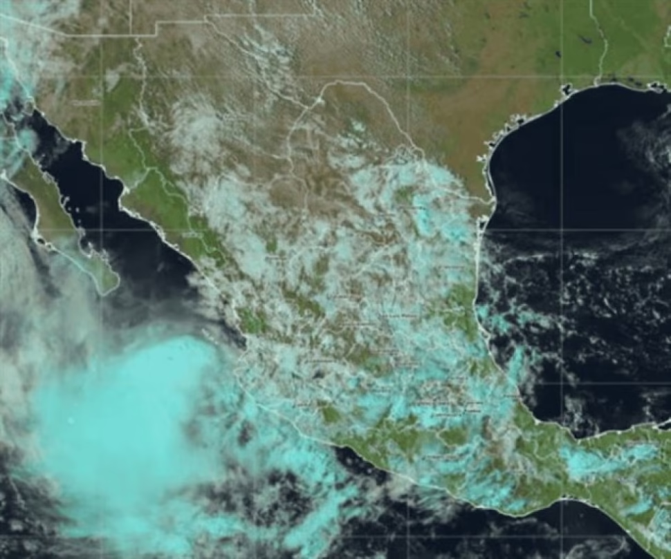
To give you precise coordinates of our undesirable “guest”: at 3:00 p.m., central Mexico time (that time when you should already be at home and not wondering if you go out), the center of tropical storm Raymond was located 150 km west-southwest of Playa Pérula, Jalisco. It’s moving northwest at 17 mph, faster than you’re running when you see the truck coming. Its maximum sustained winds are 85 km/h with gusts of 100 km/h, enough power to justify staying home watching a series without guilt.
Meanwhile, in this hurricane season’s spin-off, we have Priscilla, which has already become a post-tropical cyclone (the climate equivalent of when your ex becomes spiritual). It was located 170 km south-southwest of Punta Eugenia and 355 km west-northwest of Cabo San Lázaro, Baja California Sur. With maximum winds of 55 km/h and gusts of 75 km/h, it’s like the “economy” version of Raymond, but still capable of ruining your day. Due to its dissipation, this is the latest information on the system, which in colloquial language means: “Priscilla, it was nice while it lasted, but please go away now.”
The remnants of Priscilla will cause heavy rains in Baja California Sur and intervals of showers in Baja California, along with wind gusts of 40 to 60 km/h and waves of 2 to 3 meters. Basically, an unpleasant but manageable day, like when you have to go to a mandatory family gathering.
The authorities ask for caution (and we ask that you listen to them)
The SMN will maintain surveillance in the prevention zone for the effects of tropical storm winds from Manzanillo, Colima, to Cabo Corrientes, Jalisco, including the Marías Islands in Nayarit, and from Los Barriles to Santa Fe, Baja California Sur. That is, if you live in these areas, perhaps you should consider that today is not the best day for your photo session on the beach.
The authorities asked for extreme precautions because the rains could come with electric shocks (lightning, for friends) and cause puddles, landslides and flooding in low areas. In other words: if your house looks more like a pool than a home, perhaps you should have listened to the recommendations.
Predicted winds could blow down trees and billboards, meaning that “For Sale” billboard that’s been there for years could end up in your living room. The call is to heed the notices of the National Water Commission, follow the recommendations of Civil Protection and take extreme precautions. In other words, now is not the time to get creative with the preparation.
In short, Raymond arrived to remind us who’s boss in the Pacific, while Priscilla makes her discreet exit through the back door. The combination of heavy rain, hurricane force winds and high waves creates the perfect cocktail for a weekend of voluntary confinement. Maybe it’s a good time for that series marathon you had pending, away from windows and any object that the wind could turn into a projectile.
Have you checked your emergency kit yet? Do you have your important documents at hand? The batteries in your radio? Take advantage of the fact that you surely have an internet signal (for now) and share this information on your social networks so that your contacts in these areas stay informed and take precautions. And if you want to always be prepared for whatever the weather brings, explore more content related to weather phenomena on our site. Because better safe than sorry, especially when nature decides to get dramatic.


