Analysis of the Development and Trajectory of Tropical Cyclone Lorraine
The National Civil Protection Coordination (CNPC) has issued an alert aimed at the general population, with special emphasis on residents of northwest Mexico, urging extreme precautions in the face of the imminent effects of tropical cyclone “Lorena”. This meteorological phenomenon is currently in the development phase near the coast of Colima, with a projected trajectory that directs it towards the Baja California Sur peninsula, where its most significant impact is expected between Friday and Saturday.
The National Meteorological Service (SMN), a specialized technical body of the National Water Commission (Conagua), has provided a detailed analysis that indicates that, from the current date until next Saturday, the Lorena system will interact with the Mexican monsoon and a trough at altitude. This synergy of atmospheric patterns will cause very heavy to torrential rains, with accumulated rainfall estimated between 250 and 350 millimeters (mm), concentrated primarily in the western and northwestern regions of the national territory.
Technical Characteristics and Intensity Forecast
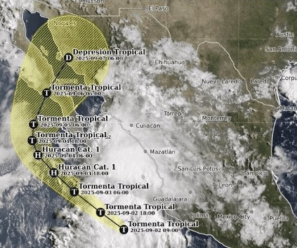
The head of Conagua, Fabián Vázquez Romaña, specified in his report at 12:15 this day that the center of Lorena was located approximately 360 kilometers (km) west of Playa Pérula, Jalisco, and 490 km south-southeast of Cabo San Lucas, Baja California Sur. The system presented maximum sustained winds of 75 kilometers per hour (km/h), with gusts that reached 95 km/h, and a movement towards the northwest at a speed of 22 km/h.
The forecast models indicate a probable intensification of the phenomenon. It is estimated that Lorraine could evolve into a Category 1 hurricane on the Saffir-Simpson scale during the course of Wednesday or Thursday, then weaken and return to its status as a tropical storm. This cycle of intensification and weakening is common in systems that transit waters with variable temperatures and that interact with changing atmospheric conditions.
States on Alert and Expected Effects
For today and tomorrow, the forecast indicates rains that will range between very heavy (50 to 75 mm) and intense (75 to 150 mm) in an extensive area that includes southern Baja California Sur, Sonora, Sinaloa, Nayarit, Jalisco, Colima and Michoacán. In addition to the precipitation, very strong to intense gusts of wind are expected on the coasts of these states. The coast of Baja California Sur is particularly critical, where gusts could reach between 100 and 120 km/h. Likewise, high waves are anticipated that will represent an additional risk for the coastal areas of the aforementioned states.
For Thursday and Friday, as the system approaches the Baja California peninsula, the rains are expected to intensify, going from intense to torrential in southern Baja California, Baja California Sur, Sonora and Sinaloa. The winds will maintain their intensity, with gusts of 100 to 120 km/h on the coasts of Baja California Sur, and with less force on the coasts of Baja California, Sonora and Sinaloa. The state of the sea will be severely affected, with waves that could reach heights of 4.5 to 6 meters on the western coast of Baja California Sur, and with minor, although significant, storm surges in the Gulf of California and the coasts of Sonora and Sinaloa.
Impact Estimation and Mitigation Measures
Track analysis suggests that Lorena is estimated to make landfall during Friday morning on the western coast of Baja California Sur. After crossing the peninsula, it is projected that it will reach the coasts of Sonora on Saturday, at which point it will begin a process of gradual weakening as it interacts with the Earth’s surface, which will lead to a gradual decrease in its effects.
Faced with this scenario, the technical areas of Conagua have reinforced special surveillance on dams, rivers and other bodies of water located in Baja California Sur, Chihuahua, Sinaloa and Sonora. Attention is focused on those reservoirs that report a filling greater than 90% of their capacity, such as Abraham González and Las Lajas, in Chihuahua, as well as Picachos and Santa María, in Sinaloa, due to the risk of spilling or overflowing due to the extraordinary rains predicted.
Regarding the emergency response capacity, Conagua has reported that its intervention brigades throughout the country, and particularly in Baja California Sur, Sonora and Sinaloa, are in a state of maximum preparation. The objective is to guarantee immediate and effective action to contribute to the care of the population that could be affected by floods, landslides or other incidents.
Civil Protection Strategies and Recommendations to the Population
Representing the national coordinator of Civil Protection, Laura Velázquez Alzúa, the director of the National Communication Center of the CNPC, Nadia Leticia Tadeo Benítez, made an emphatic call to the population to reinforce prevention and self-care measures. Primary recommendations include: avoid crossing flooded rivers, streams or fords; refrain from traveling near unstable slopes with a high probability of landslides; secure or remove from roofs and patios any object that may be projected by winds; limit unnecessary mobility during periods of heavy rain; and stay constantly informed through official communication channels.
The CNPC, in operational coordination with state and municipal governments, maintains active all civil protection protocols designed for the rainy season and tropical cyclones. Specifically for Tropical Storm Lorena, 10 early warning products have already been issued in order to strengthen preventive actions in communities at risk.
As part of these actions, the CNPC has deployed a Liaison and Coordination Mission (ECO Mission) in the state of Baja California Sur. The purpose of this mission is to support and strengthen preventive actions in which the three levels of government (federal, state and municipal) participate in a coordinated manner.
In parallel, supervision tours are carried out in areas previously identified as high risk, risk communication campaigns are developed so that the population acts in a timely manner in the event of an emergency, and verification visits are made to temporary shelters to guarantee that they comply with the required safety, habitability and health conditions, thus also mitigating the risk of epidemiological outbreaks.
The immediate response infrastructure is prepared, with a universe of 1,008 temporary shelters available and ready for activation according to the needs that arise: 169 in Baja California Sur, 236 in Colima, 477 in Jalisco and 126 in Sinaloa.
Finally, both Conagua and the CNPC reiterated the call to citizens to maintain an attitude of caution, not underestimate the strength of the meteorological phenomenon and follow to the letter the instructions issued by the Civil Protection authorities. The informed and responsible collaboration of the population is an essential component to minimize the impacts of these hydrometeorological events.
Stay informed and share this crucial information with your social media contacts to help more people prepare. Explore our site to learn more about safety protocols during cyclones.