Analysis of the Meteorological Event and its Implications
The State Coordination of Civil Protection and Risk Management (CEPCyGR) has issued a detailed report on the atmospheric conditions that will affect the Mexican territory, particularly the state of Oaxaca, during Sunday and Monday morning. The central meteorological phenomenon of this analysis is cold front number 13, a low pressure system that interacts with an air mass of Arctic origin, generating a complex climate pattern with multiple manifestations.
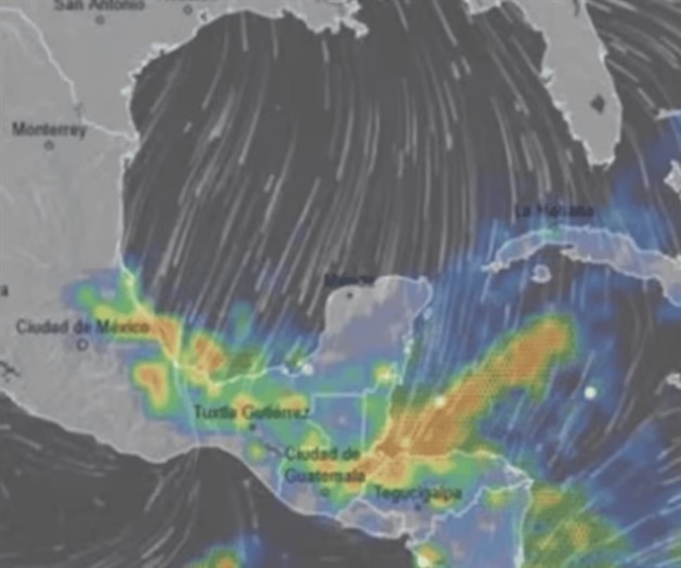
According to data provided by the National Water Commission (Conagua), this frontal system is currently moving over the Gulf of Mexico and the southeastern region of the national territory. The synoptic interaction between this front and a low pressure channel over southeastern Mexico creates ideal conditions for the formation of precipitation of varying intensity and a marked thermal decrease.
Regional Impacts and Associated Phenomena
The meteorological investigation identifies four regions of Oaxaca that will experience the most significant effects: the Sierra de Juárez, the Papaloapan Basin, the Sierra de Flores Magón and the Isthmus of Tehuantepec. In these areas, a considerable thermal drop is anticipated accompanied by rainfall of varying intensity.
Technical analysis reveals that the probability of frost will peak during dawn on Monday. At the same time, a strong to intense northern event will develop in the eastern sector of the Isthmus, with particularly significant gusts of wind in the La Venta-La Ventosa corridor. This wind pattern will extend towards the Gulf of Tehuantepec, where it will generate high waves with heights that could reach 3 meters.
The National Civil Protection Coordination (CNPC) has specified that cold front number 13 will move quickly over the northern, northeastern and eastern regions of the country. This movement will generate intense occasional rains in the states of Veracruz, Oaxaca, Chiapas and Tabasco; very heavy rainfall in Hidalgo, Veracruz and Puebla; and heavy rains in Tamaulipas, San Luis Potosí, Veracruz, Hidalgo, Puebla and the Yucatán Peninsula. Additionally, intervals of showers will be recorded in Nuevo León and Querétaro, and isolated rains in Coahuila and various states in the center of the country.
In the specific case of Oaxaca, the meteorological scenario presents significant variations throughout the day. During the morning hours, a cool to temperate environment will predominate, with cold conditions and fog banks in the mountain areas. In contrast, the afternoon will register a warm atmosphere, which will manifest as hot in the isthmus of Tehuantepec and the coasts of the region. Cloud cover will fluctuate between partly cloudy and cloudy, with intense occasional rains and possible electrical activity in the north and east of Oaxaca, as well as in the north of Chiapas.
Derived Risks and Additional Forecasts
The anticipated rainfall could generate increases in the levels of rivers and streams, landslides, flooding, flooding and reduced visibility. In the state of Guerrero, showers accompanied by electric shocks are expected, adding another element of risk to the meteorological situation.
The Arctic air mass associated with the cold front, in combination with a polar trough and the polar and subtropical jet streams, will cause a marked thermal decrease in the north, northeast, east and center of the Mexican Republic. This pattern will generate a very cold to frigid environment with frost at dawn in the states of the Mesa del Norte and the Mesa Central.
Simultaneously, a “North” event is anticipated with gusts of wind between 70 and 90 km/h and waves of 2.0 to 3.0 meters high on the coasts of Tamaulipas and Veracruz. This wind pattern will gradually extend towards the isthmus and gulf of Tehuantepec, Oaxaca and Chiapas, with gusts of 40 to 50 km/h on the coasts of Tabasco and Campeche. In addition, strong to very strong winds will be recorded in the northern and central states of Mexico.
A particularly notable phenomenon forecast for early Monday morning is the possible fall of snow or sleet on the mountain peaks of Pico de Orizaba and Cofre de Perote. On the other hand, the entry of humid air from the Pacific Ocean will generate rain and intervals of showers in areas of the west and south of the country. In the rest of the national territory, partially cloudy skies will predominate with no chance of precipitation.
This exhaustive analysis demonstrates the complexity of the current weather pattern and the importance of maintaining constant surveillance on the evolution of these atmospheric phenomena, particularly for civil protection authorities and the population in the highest risk areas.
Share this detailed meteorological analysis on your social networks and explore more content specialized in climate phenomena and risk prevention on our digital portal.