Melissa is not just passing by, she is coming to create the tropical drama of the year
It seems that the central Caribbean decided to raise the rating of the cyclone season with a new protagonist: tropical storm Melissa, which is there, over those waters hotter than a trend on Twitter, doing its thing. According to the wise men at the National Hurricane Center (NHC, for the folks), this weather system is not here to play little games; It comes with every intention of evolving into a major hurricane in less than it takes you to marathon a season of your favorite series. Their eyes are on Jamaica, Haiti and the Dominican Republic, which are officially in the impact zone. In other words, in the wrong place at the wrong time.
And before the memes and collective panic begin in Mexico, we have news that is almost a *plot twist*: for now, our territory is outside of Melissa’s destruction script. That’s right, the National Meteorological Service (SMN) was clear in ruling out direct effects. Although, realistically, the climate can never be trusted 100%, so they will keep us watching in case we get some side effects, such as more intense waves or excess humidity that could give a more tropical vibe to our southeast.
The details that they didn’t tell you and that are a real disaster mood
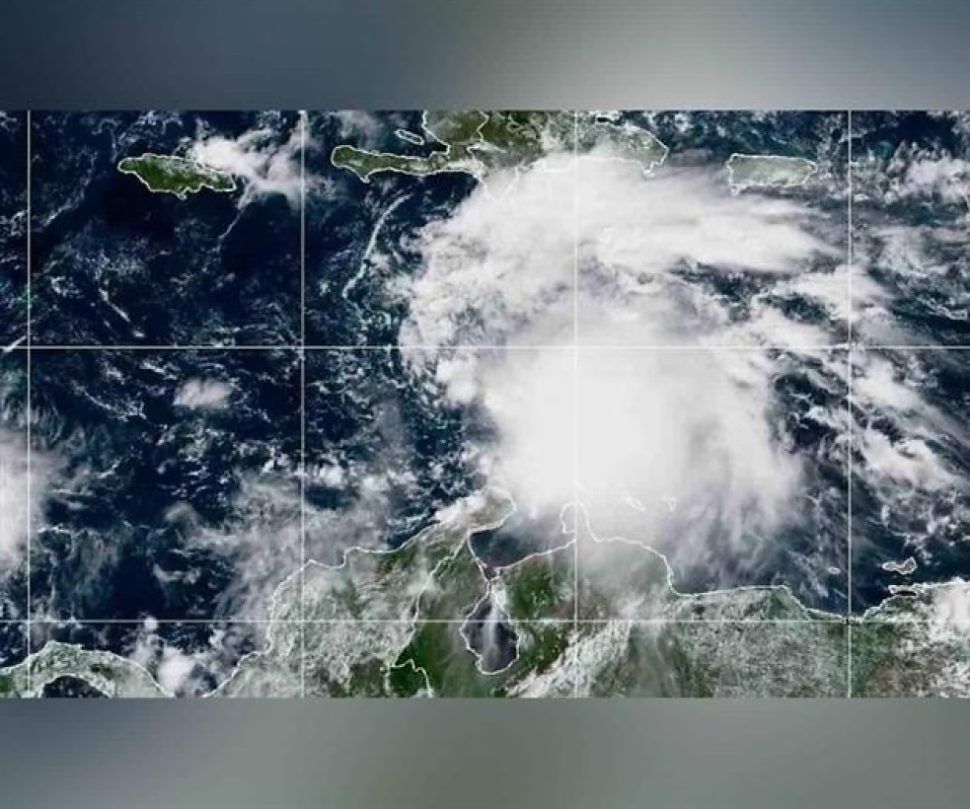
To give you an idea of what kind of natural phenomenon we are dealing with, at breakfast time this Friday (Florida time, because everything is more dramatic in international time), Melissa was positioned near Jamaica and Haiti, boasting maximum sustained winds of 85 km/h. Its movement is slow, towards the northwest, which is basically the perfect recipe for a disaster: it means that prolonged rainfall and subsequent flooding in the Greater Antilles is going to be its calling card. He’s not coming in a hurry, he’s coming to stay and cause as much chaos as possible.
The NHC forecast is so alarming that it looks like the trailer for a disaster movie. Under extremely favorable ocean and wind conditions (for the storm, obviously, not for humans), Melissa could reach category 3 or even higher in the next 48 to 72 hours. This has motivated the call to maintain alerts in Jamaica, Haiti and the Dominican Republic. Rain accumulations of between 200 and 350 millimeters are expected, and in the mountainous areas, things get worse, with projections of up to 500 millimeters. Translation: a very high potential for landslides and sudden river flooding. Basically, nature in its wildest and unfiltered state.
Meanwhile, in Mexico, we can breathe a little (but not too much). The SMN confirmed that Melissa’s trajectory remains confined to the central Caribbean and shows no intention of entering the Gulf of Mexico. Although, you know how it is, we always have to be prepared for the remnants of humidity that could influence our local climate. In short, it is a reminder of how unpredictable Mother Nature can be and the importance of staying informed through official sources.
Are you left wanting more information about meteorological phenomena? Share this article on your social networks and help more people be aware! Don’t miss our ongoing climate coverage and explore more related content on our site.